



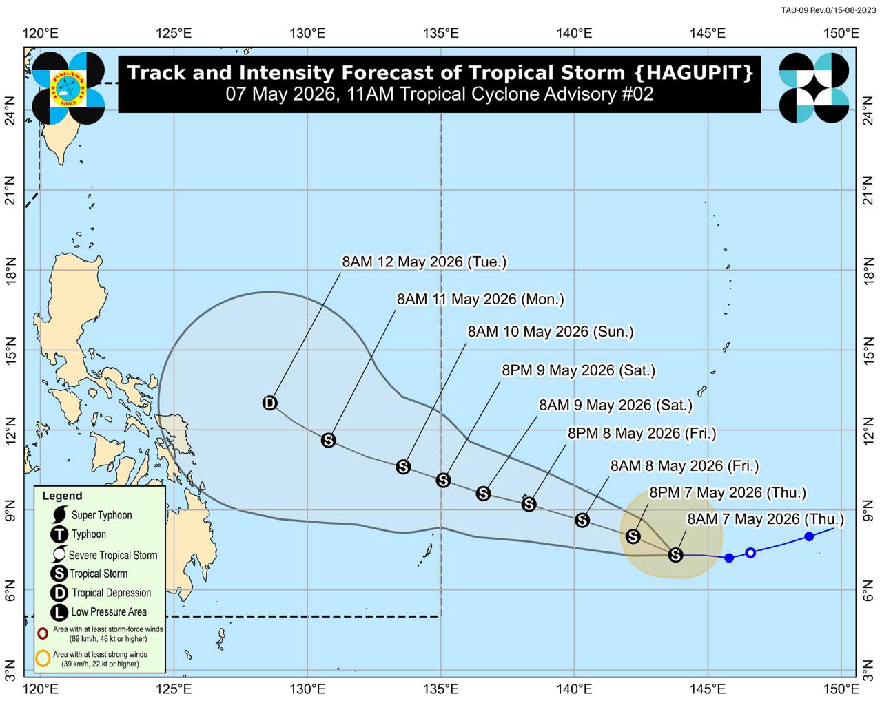

Binabantayan na ng Philippine Atmospheric, Geophysical and Astronomical Services Administration (PAGASA) ang Tropical Storm Hagupit na posibleng pumasok sa Philippine Area of Responsibility (PAR) sa gabi ng Sabado, May 9, hanggang umaga ng Linggo, May 10, at tatawaging “Caloy.”
Sa Tropical Cyclone Advisory No. 2 na inilabas alas-11 ng umaga ngayong May 7, sinabi ng PAGASA na ang Bagyong Hagupit ay nananatili ang lakas habang kumikilos pakanluran sa karagatan sa south of Guam.
Batay sa advisory, ang sentro ng bagyo ay namataan alas-10 ng umaga sa layong 1,895 kilometers east of Northeastern Mindanao, outside PAR, sa coordinates na 7.5°N, 143.5°E.
Taglay ng Hagupit ang maximum sustained winds na 65 kilometers per hour malapit sa sentro, gustiness na hanggang 80 kilometers per hour, at central pressure na 1002 hPa. Kumikilos ito pakanluran sa bilis na 20 kilometers per hour.
Ayon sa PAGASA, umaabot hanggang 280 kilometro mula sa sentro ang strong to gale-force winds ng bagyo.
“Hagupit is forecast to move west-northwest throughout the forecast period. It will enter the PAR between Saturday (09 May) evening and Sunday (10 May) morning and will be given a local name CALOY,” saad ng PAGASA.
Inaasahan ng weather bureau na lalakas pa ang Hagupit sa susunod na 48 oras at maaaring umabot sa high-end tropical storm category.
“In the next 48 hours, Hagupit will further intensify, peaking as a high-end tropical storm. Afterward, due to unfavorable environmental conditions, it will begin to weaken and may be downgraded to a tropical depression by next Tuesday (12 May) while over the Philippine Sea,” ayon sa PAGASA.
Sa ngayon, hindi pa inaasahang direktang tatama sa panahon at sea conditions sa bansa ang Hagupit sa susunod na tatlong araw.
“Hagupit is less likely to directly affect the weather and sea conditions in the next 3 days,” saad ng PAGASA.
Gayunman, pinayuhan ang publiko at disaster risk reduction and management offices na patuloy na mag-monitor ng updates kaugnay ng tropical cyclone. /Bistado